The Bioceanic Corridor is one of the most transformative infrastructure projects in South America. Designed to connect the Atlantic and Pacific Oceans across the continent, it promises to reshape regional trade, strengthen international cooperation, and boost economic activity in historically isolated regions. In Paraguay, the backbone of this vision is Ruta PY15, cutting across the heart of the Chaco. The project is divided into multiple construction sections—commonly understood as Sections I–III, with a fourth category referring to complementary works such as international bridges, access roads, and environmental measures.
This article provides an in-depth, educational look at the Bioceanic Corridor in Paraguay, focusing specifically on Sections I–IV of Ruta PY15: their purpose, engineering design, progress, expected benefits, environmental and social challenges, and broader geopolitical significance.
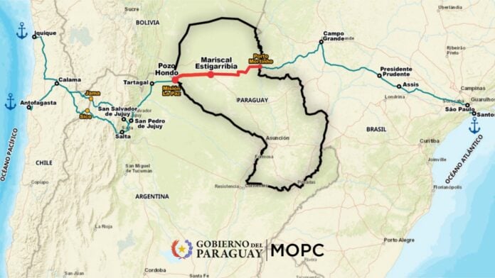
1. What Is the Bioceanic Corridor?
The Bioceanic Corridor is a transcontinental route linking the Atlantic coast of Brazil to the Pacific coast of Chile. As an integrated system of highways, bridges, customs facilities, and logistics hubs, the corridor passes through Brazil, Paraguay, Argentina, and Chile, forming a key part of what is known as the “Capricorn Axis” of South American integration.
The goal is to provide:
- A faster, more direct connection between the two oceans
- Reduced logistical costs for exporters and importers
- Increased competitiveness for South American agricultural, mining, and industrial products
- Development opportunities for remote and underserved regions
- Stronger economic ties among participating countries
Paraguay’s Role: Ruta PY15
Within Paraguay, the corridor is embodied in Ruta PY15, a national highway stretching roughly 530 km from Carmelo Peralta, on the Brazilian border, to Pozo Hondo, where Paraguay meets Argentina. The road traverses the sparsely populated Paraguayan Chaco, historically known for limited connectivity, fragile ecosystems, and large indigenous territories.
By completing PY15, Paraguay positions itself as a land bridge between two oceanic basins—transforming from a landlocked country into a continental logistics hub.
2. The Structure of the Project: Sections I–IV
Although the project is officially divided into three major “tramos,” many technical and public documents refer to four segments, with the fourth encompassing complementary works. Here is a clear explanation of each:
Section I (Eastern Section)
Route: Carmelo Peralta → Loma Plata
Approx. Length: 275 km
Status: Completed
Section I was the first major milestone of the Bioceanic Corridor in Paraguay. It provides the paved connection from the border town of Carmelo Peralta—where a major international bridge to Brazil is under construction—to the Mennonite region of Loma Plata in Boquerón.
Completing this section provided immediate benefits, including:
- Improved access to remote communities
- Reduction in travel time across the eastern Chaco
- A connection point for future segments of PY15
As the first major operational segment, it set engineering standards for the rest of the corridor.
Section II (Central Section)
Route: Cruce Centinela → Mariscal Estigarribia
Approx. Length: 138 km
Status: Partially completed / under improvement
This section connects the eastern and central Chaco. Historically, some parts had basic or partial pavement, while others were gravel or sand tracks. Under the Bioceanic Corridor program, the entire segment is being rehabilitated or fully reconstructed.
Key elements of Section II include:
- Widening and improving existing carriageways
- Adding drainage systems to address seasonal flooding
- Building safer shoulders and embankments
- Improving signage, marking, and visibility
Once upgraded, Section II ensures uninterrupted paved travel across the entire Chaco region.
Section III (Western Section)
Route: Mariscal Estigarribia → Pozo Hondo
Approx. Length: 224 km
Status: Under construction
This is the most remote and logistically challenging part of the route. Construction has been divided into four large “lots,” each handled by different contractor groups to accelerate progress.
Major works include:
- Earthworks and soil stabilization in sandy, clay-heavy terrain
- Construction of culverts, drainage systems, and underpasses
- Pavement structure (sub-base, base, and asphalt layers)
- Environmental and archaeological monitoring
- Safety infrastructure, signage, and road markings
Because Section III lies closest to the Argentine border, it is essential for completing the transcontinental route. Once finished, travelers and freight can cross into Argentina and continue toward Chile’s Pacific ports.
Section IV (Complementary Works and International Connections)
Although sometimes not counted as a “section” of the highway itself, Section IV usually refers to crucial complementary components, including:
- International bridge between Carmelo Peralta (Paraguay) and Porto Murtinho (Brazil)
- Border facilities and customs complexes
- Urban access roads and bypasses
- Environmental mitigation and wildlife crossings
- Access routes to indigenous communities and rural towns
The international bridge—an architectural and engineering centerpiece—is particularly important. It connects the corridor to Brazil’s transport network, allowing exporters and logistics operators to reach Atlantic ports as well as the Pacific route.
3. Engineering and Construction Features
The Bioceanic Corridor in Paraguay is being built to modern technical and environmental standards. Engineering features include:
- 12-meter roadway platform with a 7-meter roadway and 5 meters of shoulders
- Up to 100 meters of right-of-way to accommodate utilities, drainage, and safety zones
- Drainage systems designed for the Chaco’s extreme climate
- Wildlife passages to reduce roadkill and maintain ecological connectivity
- Urban bypasses to avoid heavy traffic in small communities
Road construction in the Chaco is particularly complex due to:
- Highly variable soil conditions
- Extreme seasonal shifts between drought and heavy rainfall
- Environmental sensitivity of surrounding ecosystems
- Cultural and archaeological heritage areas that require monitoring
The dividing of Section III into multiple lots is intended to distribute workload, increase efficiency, and accelerate completion.
4. Economic and Strategic Benefits
A. Faster and Cheaper Trade
One of the most significant advantages of the Bioceanic Corridor is reduced transport time between inland producers and global markets. For products such as soybeans, beef, minerals, and manufactured goods, the overland route can cut maritime shipping time to Asia by nearly two weeks.
B. A Continental Logistics Hub
Paraguay, long landlocked and dependent on river transport, gains access to two oceans. This shift strengthens its geopolitical position and promotes:
- Dry ports
- Logistics parks
- Cold-chain facilities
- Warehousing and distribution centers
- Multimodal hubs integrating trucking, rail, and river transport
C. Development of the Paraguayan Chaco
The Chaco’s isolation has historically restricted economic and social development. PY15 brings:
- Better access to markets
- Greater mobility for residents
- More job opportunities
- Potential for tourism and services
- Improved emergency and health access routes
During construction, local hiring has created new employment, and new businesses (fuel stations, mechanics, hospitality services) have begun appearing along the route.
5. Environmental, Social, and Cultural Challenges
A. Ecological Impacts
The Chaco is one of the world’s most important dry forest ecosystems. It hosts:
- Rare mammals (jaguars, giant anteaters, tapirs)
- Diverse birds and reptiles
- Extensive wetlands
- Endemic species
The corridor risks:
- Deforestation
- Habitat fragmentation
- Roadkill
- Long-term disruption of migration patterns
- Loss of ecosystem services
While wildlife crossings and mitigation plans exist, experts warn that they may be insufficient without stronger enforcement and monitoring.
B. Indigenous Peoples and Cultural Impacts
The region is home to several indigenous groups, notably the Ayoreo. Concerns include:
- Land grabbing and speculation
- Cultural impacts from new settlements and traffic
- Loss of traditional hunting grounds
- Road safety risks
Some tragic accidents involving indigenous individuals have already been documented. Community leaders warn that without meaningful consultation and protection, the corridor may accelerate social and cultural erosion.
C. Land Use and Deforestation Pressures
New roads often bring agriculture, ranching, and speculative development. In the Chaco, deforestation has already reached critical levels. Critics argue that the corridor could:
- Intensify agricultural expansion
- Increase cattle ranching and soy production
- Drive further forest loss unless strict land-use controls are implemented
6. Geopolitical and Regional Integration Implications
The Bioceanic Corridor aligns with a broader reorganization of South American infrastructure. It:
- Strengthens ties between Brazil, Paraguay, Argentina, and Chile
- Offers an alternative to traditional maritime choke points
- Helps inland producers reach global markets more efficiently
- Attracts international investment in logistics and transport
- Encourages cooperation on customs, regulations, and border procedures
For Paraguay, it is a historic shift from isolation to strategic centrality.
7. The Road Ahead: What to Watch
Over the next few years, attention will focus on:
- Completing the remaining lots of Section III
- Finalizing the international bridge
- Ensuring high-quality maintenance of all newly built segments
- Strengthening environmental monitoring
- Protecting indigenous rights and cultural heritage
- Developing logistics hubs to maximize economic benefits
- Enhancing cross-border customs procedures
The project’s ultimate success will depend on balancing infrastructure development with environmental integrity and social responsibility.
Conclusion
The Bioceanic Corridor, carried across Paraguay by Ruta PY15, is far more than a highway. It is a continental link between oceans, a catalyst for economic growth, and an opportunity for regional integration. The completion of Sections I–III and the complementary works of Section IV will mark a historic milestone for Paraguay and South America.
Yet the project also presents undeniable risks. The Gran Chaco is ecologically fragile and culturally significant. Without careful planning, strong enforcement of environmental protections, and genuine engagement with indigenous communities, the costs could outweigh the benefits.
As Paraguay moves forward with the final stages of the corridor, the challenge will be ensuring that this monumental project serves not only economic and logistical goals but also environmental sustainability and social justice.
No responses yet