Africa’s economic integration depends heavily on its transportation infrastructure. While the continent is rich in natural resources, expanding markets, and growing urban centers, many African countries continue to face significant gaps in road connectivity. To address this challenge, the African Union (AU), United Nations Economic Commission for Africa (UNECA), and African Development Bank (AfDB) support one of the most ambitious and long-term continental infrastructure programs ever conceived: the Trans-African Highway (TAH) Network.
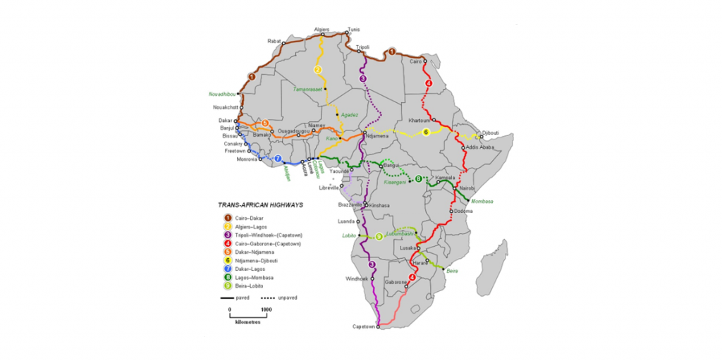
Spanning more than 56,000 kilometers, the TAH system consists of nine major corridors designed to connect nearly all regions of Africa—from the Mediterranean to the Cape, from the Atlantic to the Indian Ocean. Among these corridors, two stand out for their ongoing expansion and strategic importance:
- The Cairo–Cape Town Highway (TAH 4)
- The Dakar–Lagos Corridor (TAH 7)
Both routes are undergoing gradual improvements, upgrades, and modernization efforts aimed at stimulating trade, lowering transportation costs, and strengthening regional supply chains.
This article provides a comprehensive overview of these two major corridors, highlighting their structure, progress, challenges, and long-term significance.
1. The Trans-African Highway Network: A Continental Vision
The Trans-African Highway system is a network of trans-continental and interregional corridors established to promote:
- Easier movement of goods and people
- Continental integration under the African Continental Free Trade Area (AfCFTA)
- Development of cross-border trade routes
- Regional economic development
- Harmonization of road standards and customs procedures
The network’s long-term objective is to create a seamless web of hard-surfaced, all-weather highways connecting all African capitals and major economic hubs.
Among the nine TAH corridors, the Cairo–Cape Town and Dakar–Lagos routes are especially important because they serve large populations and connect highly active economic zones.
2. The Cairo–Cape Town Highway (TAH 4)
Overview
The Cairo–Cape Town Highway—often imagined as the African equivalent of a Pan-African “North–South” superhighway—is one of the continent’s longest and most symbolic road corridors. Stretching roughly 10,200 kilometers, it links Egypt, Sudan, Ethiopia, Kenya, Tanzania, Zambia, Zimbabwe, and South Africa.
The highway connects:
- Major production zones
- Deep-water ports (such as Durban and Port Said)
- Agricultural regions
- Rapidly growing consumer markets
- Key border crossings and trade hubs
Strategic Importance
- Trade Facilitation:
It provides the backbone of north–south trade movements in eastern and southern Africa. - Tourism and Mobility:
It offers access to iconic African destinations and supports regional tourism circuits. - Economic Development:
Countries along the corridor can expand cross-border supply chains, especially through the East African Community (EAC) and the Common Market for Eastern and Southern Africa (COMESA).
Progress and Upgrading Status
Although many sections already consist of paved, high-capacity roads, the corridor still has missing links, uneven pavement quality, and border-processing challenges.
Key developments include:
• Egypt and Sudan
- Egypt’s northern sections are fully modernized.
- A major upgrade involves the improved Argeen border crossing to ease traffic with Sudan.
- Sudan continues rehabilitating highway segments affected by conflict and extreme weather.
• Ethiopia and Kenya
- Significant progress has been made through the Moyale One-Stop Border Post, easing cargo movement between the two countries.
- Ethiopia’s road upgrades between Addis Ababa and Hawassa improve access to the corridor’s central spine.
- Kenya has upgraded large portions of the A2 highway from Nairobi to Moyale.
• Tanzania, Zambia, and Zimbabwe
- Tanzania’s segment includes paved but aging road sections undergoing phased rehabilitation.
- Zambia is upgrading segments around Tunduma and Kapiri Mposhi.
- Zimbabwe’s north–south highways are receiving incremental upgrades, although funding challenges remain.
• South Africa
- The southernmost link, entering through Beitbridge into the South African N1, is fully developed.
- South Africa’s N1 is among the best-maintained parts of the entire corridor, featuring dual carriageways in key areas.
Remaining Challenges
- Unpaved or deteriorated sections in Sudan and South Sudan (depending on alignment used).
- Border delays despite improvements in one-stop border posts.
- Funding constraints for long, rural stretches.
- Climatic impacts: flooding, desert conditions, and heavy truck wear.
- Political instability in certain regions affecting continuity.
Despite these challenges, the Cairo–Cape Town Highway remains one of the most advanced corridors in the TAH network, with modernization continuing as regional blocs expand cross-border economic activity.
3. The Dakar–Lagos Corridor (TAH 7)
Overview
The Dakar–Lagos Corridor is one of the busiest and most commercially significant routes in West Africa. Running approximately 4,000 kilometers, the corridor links Senegal, The Gambia, Guinea-Bissau, Guinea, Sierra Leone, Liberia, Côte d’Ivoire, Ghana, Togo, Benin, and Nigeria.
In practice, modern development efforts focus most intensely on the Senegal–Nigeria stretch, which forms the backbone of the Economic Community of West African States (ECOWAS) transport network.
Strategic Importance
- High Population Density:
It serves one of the most populated coastal belts in Africa, home to over 300 million people. - Trade and Logistics:
The corridor connects major seaports, regional markets, industrial zones, and free-trade areas. - Regional Integration:
Under ECOWAS protocols, the corridor is central to free movement of goods and people. - Urban Connectivity:
It links capital cities such as Dakar, Banjul, Conakry, Abidjan, Accra, Lomé, Cotonou, and Lagos.
Progress and Upgrading Status
• Senegal
- The Dakar–Diamniadio–AIBD highway system is one of West Africa’s newest, supporting fast movement of goods and travelers from Dakar to the regional interior.
- Continued upgrades toward the Gambian border improve regional travel times.
• The Gambia
- The Senegambia Bridge greatly reduced travel delays associated with previous ferry crossings.
- Additional road rehabilitation is underway on routes leading to Guinea-Bissau and Senegal.
• Guinea-Bissau, Guinea, Sierra Leone, Liberia
- These segments historically feature some of the most challenging road conditions.
- Upgrading efforts are phased, with a mix of rehabilitation, paving, and rural connectivity projects funded through regional development banks.
• Côte d’Ivoire
- Major improvements on the Abidjan–Grand-Bassam and Abidjan–Noé (Ghana border) sections.
- Expansion of port access roads enhances logistics efficiency for one of West Africa’s largest economies.
• Ghana
- Upgrading of the Accra–Tema Motorway and expansion of the coastal highway toward Togo.
- Development of new interchanges and bypasses to reduce urban congestion.
• Togo and Benin
- Upgrades to the Lomé–Cotonou and Cotonou–Sèmè routes improve sub-regional integration.
- Ongoing widening projects aim to accommodate the corridor’s heavy truck traffic.
• Nigeria
- The Lagos–Badagry Expressway, a critical gateway to Benin, is undergoing staged reconstruction and widening.
- Full completion will greatly improve mobility along one of the busiest trading corridors in West Africa.
Challenges Along the Dakar–Lagos Route
- Varying road standards between countries
- Congested border posts, especially between Ghana, Togo, Benin, and Nigeria
- Weather-related deterioration, especially during rainy seasons
- Funding gaps for large-scale highway modernization
- Urban congestion in major metropolitan areas
- Security concerns in certain segments
Despite these obstacles, the Dakar–Lagos corridor is one of the fastest-improving and commercially active segments of the Trans-African Highway system.
4. Broader Significance for Africa’s Economic Future
Both the Cairo–Cape Town and Dakar–Lagos corridors contribute to:
• AfCFTA Implementation
Improved road links enable intra-African trade, which remains far below global averages.
• Industrial Corridors
They support value chains in agriculture, mining, oil and gas, manufacturing, and services.
• Infrastructure Integration
They complement port expansions, new railways, logistics hubs, and border modernization.
• Urbanization and Mobility
They link fast-growing cities with rural and agricultural zones, enhancing access to markets.
• Tourism and Cultural Exchange
Long-distance travel becomes easier, boosting regional tourism.
The Trans-African Highway Corridors, especially the Cairo–Cape Town and Dakar–Lagos routes, are central to Africa’s long-term strategy for economic development, integration, and mobility. While challenges remain—ranging from inconsistent funding to uneven road quality and border inefficiencies—progress continues steadily across multiple countries.
As modernization projects advance, these corridors are expected to evolve into continental arteries that support faster trade, stronger regional cooperation, and broader economic opportunities. Ultimately, the transformation of the Trans-African Highway Network represents not just an infrastructure initiative, but a foundational step toward a more connected and economically unified Africa.
No responses yet